The Pays d’Enhaut
Home > Tourist Guide > Table of contents > Bernese Oberland > The Pays d’Enhaut

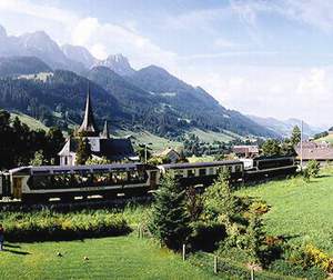
The Panoramic Express, linking Montreux to the Bernese Oberland. (©_Switzerland Tourism) |
|
|
Barely 3km west of Saanen you cross the border from Canton
Bern into Canton Vaud, and with it the linguistic Röstigraben – not a kilometre
further on is the francophone resort of Rougemont,
a charming little place full of character that is, so far, reasonably successfully
fending off the encroachment of Gstaad’s high-rollers. This area is known as
the PAYS D’ENHAUT, or Highlands, a sliver of mountain territory originally
owned by Gruyères, then seized by Bern, before forming part of the new Vaudois
territory after the 1798 revolution. The main valley, with its succession of
broad, enclosed side valleys set amidst gentle peaks carpeted by lush summer
pasture, is separated from Vaud’s better-known resorts such as Leysin and Les
Diablerets by the Col des Mosses pass (1445m) further south. West of Rougemont
is the largest town of the region, Château
d’Oex, best known as a centre for hot-air ballooning. The MOB narrow-gauge train line runs along the valley
floor from Gstaad through Château d’Oex, shortly afterwards winding its way
down alongside the Dent de Jaman to Montreux (see here for travels details). A branch line from Montbovon, some 11km west of
Château d’Oex, runs north to Gruyères (see here for travels details)..
|